|
|
|||||||||||||||||
| Point ID: 2900 | Downloads | Plots | Site Data | Code: 05MG004 |
|
|
|||||||||||||||||
| Download | |
|---|---|
| Site Descriptor Information | Site Time Series Data |
| Link to all available data | |
| View: | Time Series | All |
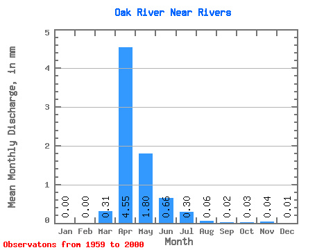
| Units: | m3/s |
| Statistic | Jan | Feb | Mar | Apr | May | Jun | Jul | Aug | Sep | Oct | Nov | Dec | Annual |
|---|---|---|---|---|---|---|---|---|---|---|---|---|---|
| Mean | 0.00 | 0.00 | 0.31 | 4.55 | 1.80 | 0.66 | 0.30 | 0.06 | 0.03 | 0.03 | 0.04 | 0.01 | 8.96 |
| Standard Deviation | 0.01 | 0.01 | 0.61 | 5.17 | 3.94 | 1.21 | 0.59 | 0.14 | 0.08 | 0.08 | 0.11 | 0.03 | 8.82 |
| Min | 0.00 | 0.00 | 0.00 | 0.00 | 0.00 | 0.00 | 0.00 | 0.00 | 0.00 | 0.00 | 0.00 | 0.00 | 0.04 |
| Max | 0.07 | 0.05 | 2.14 | 20.49 | 23.52 | 5.43 | 2.79 | 0.67 | 0.41 | 0.40 | 0.46 | 0.12 | 30.02 |
| Coefficient of Variation | 4.09 | 3.89 | 1.94 | 1.14 | 2.19 | 1.83 | 1.96 | 2.48 | 2.99 | 3.01 | 2.93 | 3.82 | 0.98 |
 Return to R-Arctic Net Home Page