|
|
|||||||||||||||||
| Point ID: 2869 | Downloads | Plots | Site Data | Code: 05LL027 |
|
|
|||||||||||||||||
| Download | |
|---|---|
| Site Descriptor Information | Site Time Series Data |
| Link to all available data | |
| View: | Time Series | All |
| Units: | m3/s |
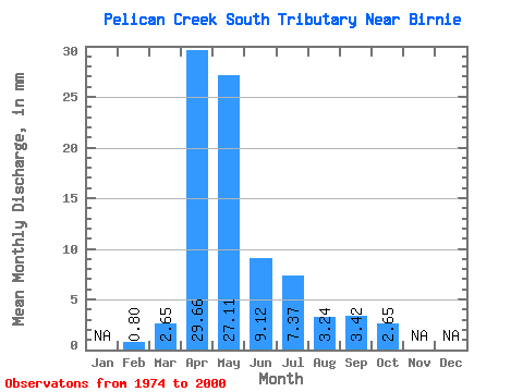
| Statistic | Jan | Feb | Mar | Apr | May | Jun | Jul | Aug | Sep | Oct | Nov | Dec | Annual |
|---|---|---|---|---|---|---|---|---|---|---|---|---|---|
| Mean | 0.81 | 2.55 | 29.72 | 27.01 | 8.99 | 7.51 | 3.12 | 3.53 | 2.52 | ||||
| Standard Deviation | 3.88 | 24.44 | 30.94 | 7.98 | 13.48 | 8.36 | 13.21 | 4.64 | |||||
| Min | 0.81 | 0.00 | 1.14 | 1.77 | 0.28 | 0.00 | 0.00 | 0.00 | 0.00 | ||||
| Max | 0.81 | 14.14 | 93.53 | 118.43 | 26.23 | 61.28 | 42.42 | 69.01 | 20.92 | ||||
| Coefficient of Variation | 1.52 | 0.82 | 1.15 | 0.89 | 1.79 | 2.68 | 3.75 | 1.84 |
 Return to R-Arctic Net Home Page