|
|
|||||||||||||||||
| Point ID: 2868 | Downloads | Plots | Site Data | Code: 05LL026 |
|
|
|||||||||||||||||
| Download | |
|---|---|
| Site Descriptor Information | Site Time Series Data |
| Link to all available data | |
| View: | Time Series | All |
| Units: | m3/s |
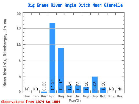
| Statistic | Jan | Feb | Mar | Apr | May | Jun | Jul | Aug | Sep | Oct | Nov | Dec | Annual |
|---|---|---|---|---|---|---|---|---|---|---|---|---|---|
| Mean | 0.33 | 17.34 | 11.16 | 1.84 | 1.82 | 1.38 | 4.02 | 1.36 | |||||
| Standard Deviation | 0.64 | 25.30 | 17.51 | 1.63 | 3.74 | 3.10 | 15.99 | 4.35 | |||||
| Min | 0.00 | 0.18 | 0.01 | 0.00 | 0.00 | 0.00 | 0.00 | 0.00 | |||||
| Max | 2.54 | 112.32 | 59.70 | 5.78 | 15.51 | 12.22 | 71.82 | 19.69 | |||||
| Coefficient of Variation | 1.94 | 1.46 | 1.57 | 0.89 | 2.05 | 2.25 | 3.98 | 3.21 |
 Return to R-Arctic Net Home Page