|
|
|||||||||||||||||
| Point ID: 2866 | Downloads | Plots | Site Data | Code: 05LL023 |
|
|
|||||||||||||||||
| Download | |
|---|---|
| Site Descriptor Information | Site Time Series Data |
| Link to all available data | |
| View: | Time Series | All |
| Units: | m3/s |
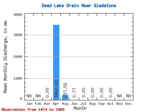
| Statistic | Jan | Feb | Mar | Apr | May | Jun | Jul | Aug | Sep | Oct | Nov | Dec | Annual |
|---|---|---|---|---|---|---|---|---|---|---|---|---|---|
| Mean | 0.07 | 3460.37 | 237.58 | 1.09 | 0.00 | 0.00 | 0.19 | 0.07 | |||||
| Standard Deviation | 0.23 | 5561.64 | 471.62 | 2.95 | 0.00 | 0.00 | 0.67 | 0.23 | |||||
| Min | 0.00 | 0.00 | 0.00 | 0.00 | 0.00 | 0.00 | 0.00 | 0.00 | |||||
| Max | 0.80 | 15891.43 | 1506.38 | 10.03 | 0.00 | 0.00 | 2.31 | 0.80 | |||||
| Coefficient of Variation | 3.46 | 1.61 | 1.98 | 2.70 | 3.46 | 3.46 |
 Return to R-Arctic Net Home Page