|
|
|||||||||||||||||
| Point ID: 2865 | Downloads | Plots | Site Data | Code: 05LL022 |
|
|
|||||||||||||||||
| Download | |
|---|---|
| Site Descriptor Information | Site Time Series Data |
| Link to all available data | |
| View: | Time Series | All |
| Units: | m3/s |
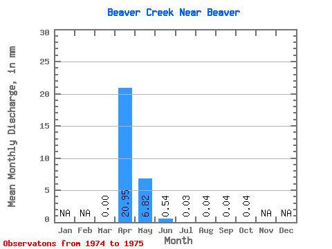
| Statistic | Jan | Feb | Mar | Apr | May | Jun | Jul | Aug | Sep | Oct | Nov | Dec | Annual |
|---|---|---|---|---|---|---|---|---|---|---|---|---|---|
| Mean | 0.00 | 20.95 | 6.82 | 0.55 | 0.03 | 0.04 | 0.04 | 0.04 | |||||
| Standard Deviation | 0.00 | 20.44 | 7.16 | 0.27 | 0.04 | 0.04 | 0.06 | 0.05 | |||||
| Min | 0.00 | 6.50 | 1.76 | 0.35 | 0.00 | 0.01 | 0.00 | 0.00 | |||||
| Max | 0.00 | 35.40 | 11.88 | 0.74 | 0.05 | 0.06 | 0.09 | 0.07 | |||||
| Coefficient of Variation | 0.98 | 1.05 | 0.50 | 1.41 | 1.01 | 1.41 | 1.41 |
 Return to R-Arctic Net Home Page