|
|
|||||||||||||||||
| Point ID: 2864 | Downloads | Plots | Site Data | Code: 05LL021 |
|
|
|||||||||||||||||
| Download | |
|---|---|
| Site Descriptor Information | Site Time Series Data |
| Link to all available data | |
| View: | Time Series | All |
| Units: | m3/s |
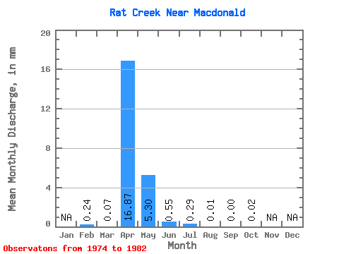
| Statistic | Jan | Feb | Mar | Apr | May | Jun | Jul | Aug | Sep | Oct | Nov | Dec | Annual |
|---|---|---|---|---|---|---|---|---|---|---|---|---|---|
| Mean | 0.24 | 0.07 | 16.87 | 5.30 | 0.55 | 0.30 | 0.01 | 0.00 | 0.02 | ||||
| Standard Deviation | 0.13 | 22.07 | 8.53 | 0.65 | 0.53 | 0.01 | 0.00 | 0.05 | |||||
| Min | 0.24 | 0.00 | 0.02 | 0.01 | 0.00 | 0.00 | 0.00 | 0.00 | 0.00 | ||||
| Max | 0.24 | 0.31 | 55.21 | 22.23 | 2.10 | 1.43 | 0.04 | 0.01 | 0.15 | ||||
| Coefficient of Variation | 1.91 | 1.31 | 1.61 | 1.18 | 1.79 | 1.38 | 1.98 | 2.42 |
 Return to R-Arctic Net Home Page