|
|
|||||||||||||||||
| Point ID: 2846 | Downloads | Plots | Site Data | Code: 05LJ048 |
|
|
|||||||||||||||||
| Download | |
|---|---|
| Site Descriptor Information | Site Time Series Data |
| Link to all available data | |
| View: | Time Series | All |
| Units: | m3/s |
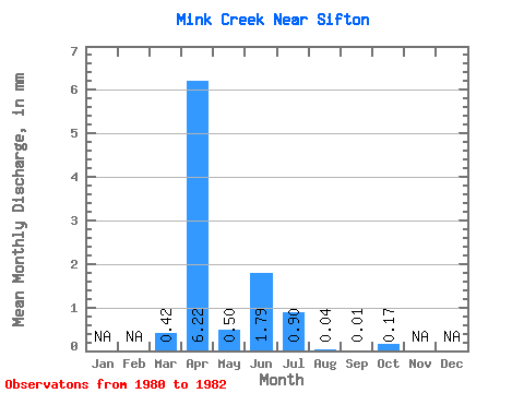
| Statistic | Jan | Feb | Mar | Apr | May | Jun | Jul | Aug | Sep | Oct | Nov | Dec | Annual |
|---|---|---|---|---|---|---|---|---|---|---|---|---|---|
| Mean | 0.42 | 6.21 | 0.49 | 1.79 | 0.89 | 0.04 | 0.01 | 0.17 | |||||
| Standard Deviation | 0.38 | 5.19 | 0.47 | 3.02 | 1.13 | 0.04 | 0.01 | 0.28 | |||||
| Min | 0.00 | 0.41 | 0.21 | 0.00 | 0.00 | 0.01 | 0.00 | 0.00 | |||||
| Max | 0.74 | 10.41 | 1.03 | 5.28 | 2.16 | 0.08 | 0.01 | 0.50 | |||||
| Coefficient of Variation | 0.91 | 0.84 | 0.95 | 1.69 | 1.26 | 0.81 | 0.87 | 1.63 |
 Return to R-Arctic Net Home Page