|
|
|||||||||||||||||
| Point ID: 2838 | Downloads | Plots | Site Data | Code: 05LJ030 |
|
|
|||||||||||||||||
| Download | |
|---|---|
| Site Descriptor Information | Site Time Series Data |
| Link to all available data | |
| View: | Time Series | All |
| Units: | m3/s |
| Statistic | Jan | Feb | Mar | Apr | May | Jun | Jul | Aug | Sep | Oct | Nov | Dec | Annual |
|---|---|---|---|---|---|---|---|---|---|---|---|---|---|
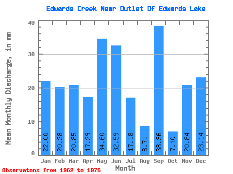
| Mean | 22.04 | 20.38 | 20.95 | 17.33 | 34.61 | 32.50 | 17.21 | 8.67 | 38.36 | 7.13 | 20.94 | 23.05 | 264.37 |
| Standard Deviation | 4.75 | 3.87 | 4.75 | 9.90 | 53.25 | 41.45 | 24.82 | 7.36 | 103.97 | 8.08 | 6.68 | 5.60 | 146.63 |
| Min | 15.12 | 15.45 | 14.43 | 0.22 | 1.38 | 2.00 | 1.15 | 0.23 | 0.67 | 0.46 | 9.76 | 15.58 | 127.11 |
| Max | 32.53 | 29.01 | 34.13 | 38.14 | 179.60 | 133.92 | 97.13 | 22.22 | 399.11 | 32.07 | 33.48 | 35.05 | 655.59 |
| Coefficient of Variation | 0.22 | 0.19 | 0.23 | 0.57 | 1.54 | 1.27 | 1.44 | 0.85 | 2.71 | 1.13 | 0.32 | 0.24 | 0.56 |
 Return to R-Arctic Net Home Page