|
|
|||||||||||||||||
| Point ID: 2834 | Downloads | Plots | Site Data | Code: 05LJ025 |
|
|
|||||||||||||||||
| Download | |
|---|---|
| Site Descriptor Information | Site Time Series Data |
| Link to all available data | |
| View: | Time Series | All |
| Units: | m3/s |
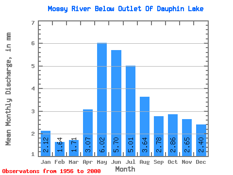
| Statistic | Jan | Feb | Mar | Apr | May | Jun | Jul | Aug | Sep | Oct | Nov | Dec | Annual |
|---|---|---|---|---|---|---|---|---|---|---|---|---|---|
| Mean | 2.12 | 1.65 | 1.71 | 3.07 | 6.02 | 5.70 | 5.00 | 3.64 | 2.78 | 2.86 | 2.65 | 2.40 | 41.01 |
| Standard Deviation | 2.07 | 1.65 | 1.66 | 2.65 | 5.41 | 5.56 | 4.82 | 3.79 | 2.96 | 3.01 | 2.56 | 2.34 | 30.57 |
| Min | 0.01 | 0.00 | 0.01 | 0.04 | 0.04 | 0.00 | 0.02 | 0.01 | 0.01 | 0.01 | 0.01 | 0.01 | 0.85 |
| Max | 8.53 | 6.70 | 6.43 | 10.85 | 19.36 | 20.44 | 16.68 | 12.65 | 9.86 | 12.93 | 11.41 | 10.31 | 110.40 |
| Coefficient of Variation | 0.98 | 1.00 | 0.97 | 0.86 | 0.90 | 0.97 | 0.96 | 1.04 | 1.06 | 1.05 | 0.97 | 0.98 | 0.74 |
 Return to R-Arctic Net Home Page