|
|
|||||||||||||||||
| Point ID: 2822 | Downloads | Plots | Site Data | Code: 05LJ012 |
|
|
|||||||||||||||||
| Download | |
|---|---|
| Site Descriptor Information | Site Time Series Data |
| Link to all available data | |
| View: | Time Series | All |
| Units: | m3/s |
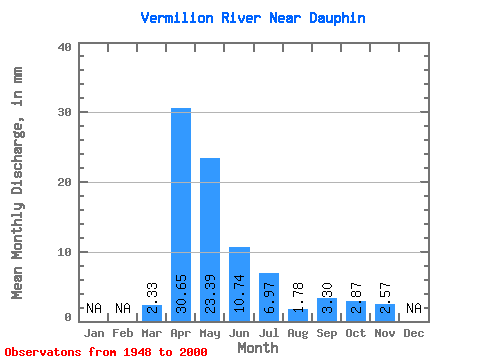
| Statistic | Jan | Feb | Mar | Apr | May | Jun | Jul | Aug | Sep | Oct | Nov | Dec | Annual |
|---|---|---|---|---|---|---|---|---|---|---|---|---|---|
| Mean | 2.33 | 30.65 | 23.39 | 10.75 | 6.96 | 1.78 | 3.30 | 2.87 | 2.57 | ||||
| Standard Deviation | 3.04 | 23.52 | 23.10 | 14.31 | 9.95 | 2.26 | 8.84 | 3.47 | 1.95 | ||||
| Min | 0.11 | 1.94 | 1.03 | 0.31 | 0.08 | 0.04 | 0.01 | 0.02 | 0.40 | ||||
| Max | 17.09 | 101.53 | 96.15 | 75.38 | 40.92 | 13.11 | 61.15 | 16.73 | 4.15 | ||||
| Coefficient of Variation | 1.31 | 0.77 | 0.99 | 1.33 | 1.43 | 1.27 | 2.68 | 1.21 | 0.76 |
 Return to R-Arctic Net Home Page