|
|
|||||||||||||||||
| Point ID: 2819 | Downloads | Plots | Site Data | Code: 05LJ007 |
|
|
|||||||||||||||||
| Download | |
|---|---|
| Site Descriptor Information | Site Time Series Data |
| Link to all available data | |
| View: | Time Series | All |
| Units: | m3/s |
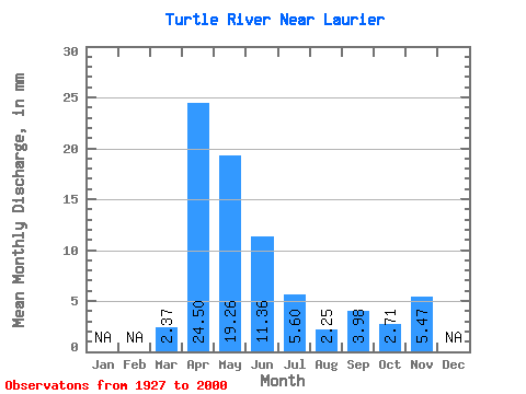
| Statistic | Jan | Feb | Mar | Apr | May | Jun | Jul | Aug | Sep | Oct | Nov | Dec | Annual |
|---|---|---|---|---|---|---|---|---|---|---|---|---|---|
| Mean | 2.37 | 24.50 | 19.26 | 11.36 | 5.59 | 2.25 | 3.99 | 2.71 | 5.47 | ||||
| Standard Deviation | 3.27 | 18.55 | 18.04 | 13.72 | 7.03 | 3.55 | 14.15 | 3.56 | |||||
| Min | 0.00 | 2.38 | 1.57 | 0.45 | 0.10 | 0.00 | 0.03 | 0.26 | 5.47 | ||||
| Max | 12.48 | 108.32 | 75.37 | 66.60 | 36.26 | 23.35 | 105.01 | 24.15 | 5.47 | ||||
| Coefficient of Variation | 1.38 | 0.76 | 0.94 | 1.21 | 1.26 | 1.58 | 3.55 | 1.31 |
 Return to R-Arctic Net Home Page