|
|
|||||||||||||||||
| Point ID: 2816 | Downloads | Plots | Site Data | Code: 05LJ002 |
|
|
|||||||||||||||||
| Download | |
|---|---|
| Site Descriptor Information | Site Time Series Data |
| Link to all available data | |
| View: | Time Series | All |
| Units: | m3/s |
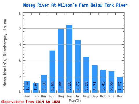
| Statistic | Jan | Feb | Mar | Apr | May | Jun | Jul | Aug | Sep | Oct | Nov | Dec | Annual |
|---|---|---|---|---|---|---|---|---|---|---|---|---|---|
| Mean | 1.74 | 1.61 | 2.10 | 3.63 | 4.95 | 5.20 | 4.26 | 3.23 | 2.71 | 2.42 | 2.33 | 1.97 | 35.28 |
| Standard Deviation | 1.72 | 1.49 | 1.65 | 2.99 | 4.29 | 3.29 | 2.29 | 2.19 | 2.06 | 1.68 | 1.89 | 1.94 | 23.35 |
| Min | 0.14 | 0.11 | 0.11 | 0.72 | 1.43 | 1.36 | 1.56 | 1.00 | 0.76 | 0.87 | 0.62 | 0.52 | 13.77 |
| Max | 5.13 | 4.62 | 5.55 | 10.64 | 14.24 | 9.90 | 8.60 | 7.89 | 6.19 | 5.44 | 6.17 | 5.53 | 82.67 |
| Coefficient of Variation | 0.99 | 0.93 | 0.78 | 0.82 | 0.87 | 0.63 | 0.54 | 0.68 | 0.76 | 0.69 | 0.81 | 0.99 | 0.66 |
 Return to R-Arctic Net Home Page