|
|
|||||||||||||||||
| Point ID: 2804 | Downloads | Plots | Site Data | Code: 05LF001 |
|
|
|||||||||||||||||
| Download | |
|---|---|
| Site Descriptor Information | Site Time Series Data |
| Link to all available data | |
| View: | Time Series | All |
| Units: | m3/s |
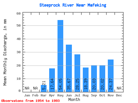
| Statistic | Jan | Feb | Mar | Apr | May | Jun | Jul | Aug | Sep | Oct | Nov | Dec | Annual |
|---|---|---|---|---|---|---|---|---|---|---|---|---|---|
| Mean | 5.20 | 17.64 | 54.04 | 35.67 | 28.25 | 18.39 | 20.03 | 20.02 | 24.37 | ||||
| Standard Deviation | 2.12 | 8.40 | 32.83 | 24.79 | 22.15 | 16.90 | 15.30 | 12.85 | |||||
| Min | 0.55 | 6.83 | 12.37 | 6.85 | 1.68 | 1.54 | 2.20 | 2.34 | 24.37 | ||||
| Max | 10.59 | 39.01 | 157.48 | 110.22 | 104.09 | 77.67 | 73.02 | 56.23 | 24.37 | ||||
| Coefficient of Variation | 0.41 | 0.48 | 0.61 | 0.69 | 0.78 | 0.92 | 0.76 | 0.64 |
 Return to R-Arctic Net Home Page