|
|
|||||||||||||||||
| Point ID: 2794 | Downloads | Plots | Site Data | Code: 05LC005 |
|
|
|||||||||||||||||
| Download | |
|---|---|
| Site Descriptor Information | Site Time Series Data |
| Link to all available data | |
| View: | Time Series | All |
| Units: | m3/s |
| Statistic | Jan | Feb | Mar | Apr | May | Jun | Jul | Aug | Sep | Oct | Nov | Dec | Annual |
|---|---|---|---|---|---|---|---|---|---|---|---|---|---|
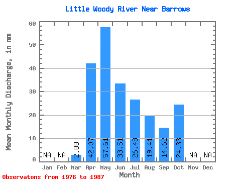
| Mean | 2.87 | 42.07 | 57.62 | 33.53 | 26.49 | 19.41 | 14.61 | 24.34 | |||||
| Standard Deviation | 1.29 | 23.32 | 39.49 | 24.19 | 20.26 | 26.21 | 11.23 | 14.70 | |||||
| Min | 0.00 | 12.27 | 9.41 | 7.07 | 5.57 | 1.84 | 1.97 | 5.92 | |||||
| Max | 5.46 | 91.12 | 122.97 | 76.62 | 79.16 | 86.85 | 42.77 | 43.04 | |||||
| Coefficient of Variation | 0.45 | 0.55 | 0.69 | 0.72 | 0.77 | 1.35 | 0.77 | 0.60 |
 Return to R-Arctic Net Home Page