|
|
|||||||||||||||||
| Point ID: 2767 | Downloads | Plots | Site Data | Code: 10BE008 |
|
|
|||||||||||||||||
| Download | |
|---|---|
| Site Descriptor Information | Site Time Series Data |
| Link to all available data | |
| View: | Time Series | All |
| Units: | m3/s |
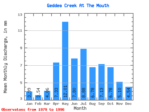
| Statistic | Jan | Feb | Mar | Apr | May | Jun | Jul | Aug | Sep | Oct | Nov | Dec | Annual |
|---|---|---|---|---|---|---|---|---|---|---|---|---|---|
| Mean | 4.01 | 3.57 | 4.05 | 7.33 | 12.00 | 7.81 | 8.89 | 6.78 | 7.12 | 6.78 | 5.11 | 4.56 | 77.21 |
| Standard Deviation | 1.18 | 0.99 | 1.20 | 3.90 | 6.73 | 4.14 | 9.21 | 2.86 | 2.17 | 2.19 | 1.65 | 1.39 | 28.17 |
| Min | 2.10 | 1.91 | 1.82 | 3.00 | 4.06 | 2.96 | 3.37 | 3.30 | 3.53 | 3.30 | 2.53 | 1.89 | 42.39 |
| Max | 6.85 | 5.24 | 5.96 | 19.99 | 26.78 | 17.46 | 42.34 | 13.22 | 11.36 | 10.95 | 8.50 | 7.47 | 143.43 |
| Coefficient of Variation | 0.29 | 0.28 | 0.30 | 0.53 | 0.56 | 0.53 | 1.03 | 0.42 | 0.30 | 0.32 | 0.32 | 0.30 | 0.36 |
 Return to R-Arctic Net Home Page