|
|
|||||||||||||||||
| Point ID: 2746 | Downloads | Plots | Site Data | Code: 09AA013 |
|
|
|||||||||||||||||
| Download | |
|---|---|
| Site Descriptor Information | Site Time Series Data |
| Link to all available data | |
| View: | Time Series | All |
| Units: | m3/s |
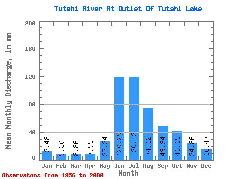
| Statistic | Jan | Feb | Mar | Apr | May | Jun | Jul | Aug | Sep | Oct | Nov | Dec | Annual |
|---|---|---|---|---|---|---|---|---|---|---|---|---|---|
| Mean | 12.47 | 9.38 | 8.86 | 7.95 | 27.23 | 120.29 | 120.10 | 74.11 | 49.34 | 41.14 | 24.86 | 16.47 | 513.26 |
| Standard Deviation | 2.44 | 1.64 | 1.41 | 1.27 | 16.30 | 28.55 | 28.30 | 12.24 | 10.74 | 11.84 | 6.80 | 3.86 | 74.25 |
| Min | 7.67 | 5.71 | 5.86 | 5.70 | 8.96 | 70.29 | 70.19 | 43.73 | 32.14 | 21.35 | 12.41 | 9.15 | 351.42 |
| Max | 17.33 | 12.94 | 12.15 | 11.18 | 75.59 | 186.82 | 184.11 | 97.72 | 78.91 | 68.84 | 38.41 | 24.70 | 655.14 |
| Coefficient of Variation | 0.20 | 0.17 | 0.16 | 0.16 | 0.60 | 0.24 | 0.24 | 0.17 | 0.22 | 0.29 | 0.27 | 0.23 | 0.14 |
 Return to R-Arctic Net Home Page