|
|
|||||||||||||||||
| Point ID: 261 | Downloads | Plots | Site Data | Code: 05BF010 |
|
|
|||||||||||||||||
| Download | |
|---|---|
| Site Descriptor Information | Site Time Series Data |
| Link to all available data | |
| View: | Time Series | All |
| Units: | m3/s |
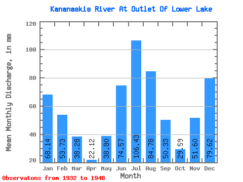
| Statistic | Jan | Feb | Mar | Apr | May | Jun | Jul | Aug | Sep | Oct | Nov | Dec | Annual |
|---|---|---|---|---|---|---|---|---|---|---|---|---|---|
| Mean | 68.13 | 54.19 | 38.28 | 22.12 | 38.80 | 74.56 | 106.42 | 84.77 | 50.33 | 29.59 | 51.60 | 79.61 | 736.28 |
| Standard Deviation | 35.70 | 37.24 | 35.28 | 21.64 | 25.57 | 65.09 | 74.24 | 58.91 | 40.50 | 21.18 | 40.36 | 42.83 | 132.03 |
| Min | 11.65 | 7.12 | 2.65 | 2.88 | 10.75 | 24.67 | 15.45 | 5.58 | 2.53 | 2.12 | 13.21 | 4.67 | 549.85 |
| Max | 128.36 | 103.70 | 99.01 | 62.93 | 90.00 | 231.78 | 215.01 | 157.07 | 115.64 | 78.15 | 127.11 | 142.91 | 904.88 |
| Coefficient of Variation | 0.52 | 0.69 | 0.92 | 0.98 | 0.66 | 0.87 | 0.70 | 0.69 | 0.81 | 0.72 | 0.78 | 0.54 | 0.18 |
 Return to R-Arctic Net Home Page