|
|
|||||||||||||||||
| Point ID: 258 | Downloads | Plots | Site Data | Code: 05BF003 |
|
|
|||||||||||||||||
| Download | |
|---|---|
| Site Descriptor Information | Site Time Series Data |
| Link to all available data | |
| View: | Time Series | All |
| Units: | m3/s |
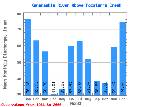
| Statistic | Jan | Feb | Mar | Apr | May | Jun | Jul | Aug | Sep | Oct | Nov | Dec | Annual |
|---|---|---|---|---|---|---|---|---|---|---|---|---|---|
| Mean | 76.06 | 63.72 | 56.69 | 31.01 | 33.87 | 59.97 | 62.72 | 51.93 | 38.89 | 37.65 | 59.07 | 74.49 | 639.51 |
| Standard Deviation | 25.94 | 26.20 | 31.38 | 20.75 | 25.15 | 57.60 | 50.89 | 34.10 | 22.78 | 18.39 | 25.58 | 21.98 | 99.39 |
| Min | 13.83 | 8.49 | 0.69 | 1.31 | 1.37 | 0.36 | 2.01 | 2.35 | 1.33 | 1.58 | 15.75 | 10.21 | 430.17 |
| Max | 130.94 | 132.11 | 127.98 | 89.50 | 105.79 | 220.53 | 197.52 | 127.24 | 100.24 | 85.08 | 117.43 | 122.80 | 861.80 |
| Coefficient of Variation | 0.34 | 0.41 | 0.55 | 0.67 | 0.74 | 0.96 | 0.81 | 0.66 | 0.59 | 0.49 | 0.43 | 0.29 | 0.15 |
 Return to R-Arctic Net Home Page