|
|
|||||||||||||||||
| Point ID: 256 | Downloads | Plots | Site Data | Code: 05BF001 |
|
|
|||||||||||||||||
| Download | |
|---|---|
| Site Descriptor Information | Site Time Series Data |
| Link to all available data | |
| View: | Time Series | All |
| Units: | m3/s |
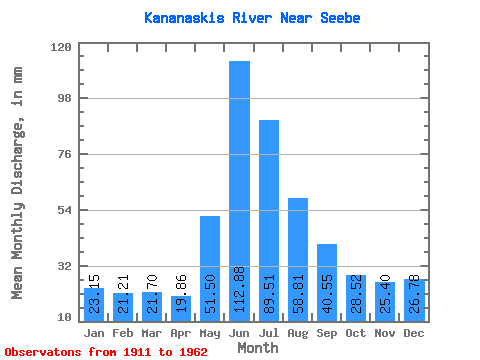
| Statistic | Jan | Feb | Mar | Apr | May | Jun | Jul | Aug | Sep | Oct | Nov | Dec | Annual |
|---|---|---|---|---|---|---|---|---|---|---|---|---|---|
| Mean | 23.15 | 21.39 | 21.70 | 19.86 | 51.49 | 112.88 | 89.50 | 58.80 | 40.55 | 28.52 | 25.40 | 26.78 | 519.25 |
| Standard Deviation | 15.18 | 16.69 | 15.80 | 11.09 | 21.17 | 51.75 | 43.06 | 27.76 | 17.88 | 9.40 | 10.91 | 15.00 | 97.57 |
| Min | 6.52 | 5.28 | 5.77 | 7.25 | 18.60 | 35.56 | 16.48 | 14.67 | 11.59 | 14.64 | 10.78 | 5.20 | 352.41 |
| Max | 65.44 | 73.23 | 64.30 | 48.62 | 96.73 | 246.70 | 231.35 | 120.55 | 89.46 | 53.96 | 49.73 | 59.70 | 853.50 |
| Coefficient of Variation | 0.66 | 0.78 | 0.73 | 0.56 | 0.41 | 0.46 | 0.48 | 0.47 | 0.44 | 0.33 | 0.43 | 0.56 | 0.19 |
 Return to R-Arctic Net Home Page