|
|
|||||||||||||||||
| Point ID: 250 | Downloads | Plots | Site Data | Code: 05BE004 |
|
|
|||||||||||||||||
| Download | |
|---|---|
| Site Descriptor Information | Site Time Series Data |
| Link to all available data | |
| View: | Time Series | All |
| Units: | m3/s |
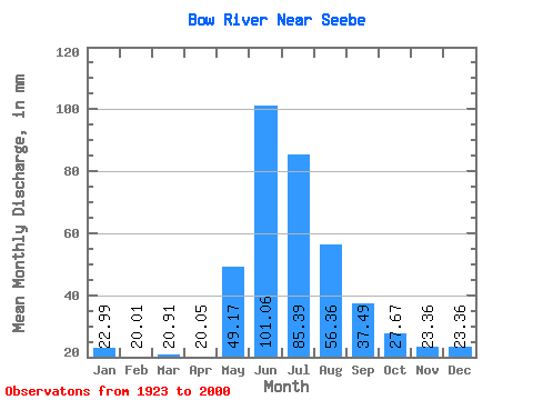
| Statistic | Jan | Feb | Mar | Apr | May | Jun | Jul | Aug | Sep | Oct | Nov | Dec | Annual |
|---|---|---|---|---|---|---|---|---|---|---|---|---|---|
| Mean | 22.99 | 20.18 | 20.91 | 20.05 | 49.16 | 101.06 | 85.38 | 56.36 | 37.49 | 27.67 | 23.36 | 23.36 | 487.13 |
| Standard Deviation | 7.32 | 6.43 | 7.02 | 5.76 | 16.95 | 32.56 | 24.31 | 12.00 | 7.74 | 5.34 | 5.62 | 6.73 | 71.69 |
| Min | 8.60 | 9.16 | 8.18 | 9.28 | 20.88 | 57.66 | 48.12 | 38.64 | 26.62 | 17.82 | 13.39 | 12.38 | 333.51 |
| Max | 35.74 | 31.95 | 36.73 | 31.18 | 100.49 | 207.06 | 152.81 | 94.27 | 61.67 | 41.96 | 35.05 | 37.40 | 641.37 |
| Coefficient of Variation | 0.32 | 0.32 | 0.34 | 0.29 | 0.34 | 0.32 | 0.28 | 0.21 | 0.21 | 0.19 | 0.24 | 0.29 | 0.15 |
 Return to R-Arctic Net Home Page