|
|
|||||||||||||||||
| Point ID: 236 | Downloads | Plots | Site Data | Code: 05BB004 |
|
|
|||||||||||||||||
| Download | |
|---|---|
| Site Descriptor Information | Site Time Series Data |
| Link to all available data | |
| View: | Time Series | All |
| Units: | m3/s |
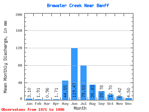
| Statistic | Jan | Feb | Mar | Apr | May | Jun | Jul | Aug | Sep | Oct | Nov | Dec | Annual |
|---|---|---|---|---|---|---|---|---|---|---|---|---|---|
| Mean | 3.09 | 1.93 | 0.95 | 1.70 | 44.54 | 119.48 | 79.01 | 35.83 | 20.78 | 12.69 | 8.43 | 4.50 | 421.99 |
| Standard Deviation | 1.46 | 0.97 | 0.81 | 1.80 | 25.06 | 41.34 | 30.29 | 11.74 | 7.75 | 3.83 | 4.34 | 2.59 | 71.33 |
| Min | 1.52 | 1.28 | 0.47 | 0.19 | 8.01 | 71.58 | 31.94 | 16.19 | 8.56 | 4.25 | 5.23 | 1.57 | 371.55 |
| Max | 5.04 | 3.36 | 2.16 | 4.21 | 102.70 | 210.21 | 150.85 | 62.16 | 39.71 | 18.92 | 13.36 | 6.49 | 472.44 |
| Coefficient of Variation | 0.47 | 0.50 | 0.85 | 1.06 | 0.56 | 0.35 | 0.38 | 0.33 | 0.37 | 0.30 | 0.52 | 0.57 | 0.17 |
 Return to R-Arctic Net Home Page