|
|
|||||||||||||||||
| Point ID: 228 | Downloads | Plots | Site Data | Code: 05BA006 |
|
|
|||||||||||||||||
| Download | |
|---|---|
| Site Descriptor Information | Site Time Series Data |
| Link to all available data | |
| View: | Time Series | All |
| Units: | m3/s |
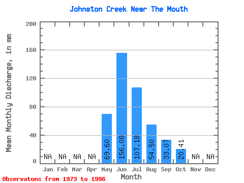
| Statistic | Jan | Feb | Mar | Apr | May | Jun | Jul | Aug | Sep | Oct | Nov | Dec | Annual |
|---|---|---|---|---|---|---|---|---|---|---|---|---|---|
| Mean | 69.58 | 156.08 | 107.16 | 54.49 | 33.06 | 20.41 | |||||||
| Standard Deviation | 33.07 | 48.49 | 38.28 | 19.93 | 11.27 | 3.96 | |||||||
| Min | 24.19 | 92.81 | 58.53 | 28.29 | 21.95 | 15.42 | |||||||
| Max | 142.11 | 257.11 | 203.01 | 110.58 | 73.58 | 27.86 | |||||||
| Coefficient of Variation | 0.47 | 0.31 | 0.36 | 0.37 | 0.34 | 0.19 |
 Return to R-Arctic Net Home Page