|
|
|||||||||||||||||
| Point ID: 226 | Downloads | Plots | Site Data | Code: 05BA004 |
|
|
|||||||||||||||||
| Download | |
|---|---|
| Site Descriptor Information | Site Time Series Data |
| Link to all available data | |
| View: | Time Series | All |
| Units: | m3/s |
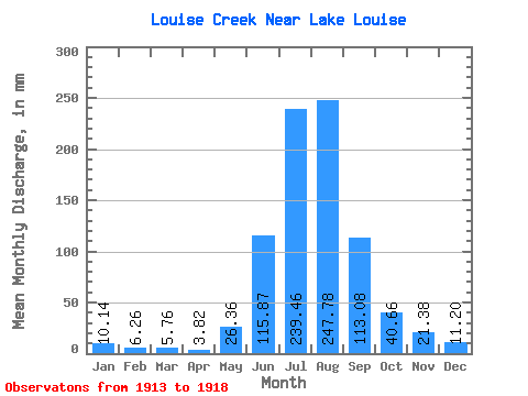
| Statistic | Jan | Feb | Mar | Apr | May | Jun | Jul | Aug | Sep | Oct | Nov | Dec | Annual |
|---|---|---|---|---|---|---|---|---|---|---|---|---|---|
| Mean | 10.16 | 6.36 | 5.74 | 3.78 | 26.33 | 115.86 | 239.42 | 247.71 | 113.04 | 40.61 | 21.36 | 11.22 | 820.04 |
| Standard Deviation | 8.75 | 7.23 | 7.71 | 4.15 | 8.32 | 28.61 | 25.76 | 33.37 | 18.45 | 28.77 | 8.26 | 7.97 | 70.19 |
| Min | 0.96 | 0.97 | 1.28 | 0.72 | 13.12 | 83.65 | 203.78 | 221.92 | 86.54 | 19.63 | 10.64 | 1.92 | 757.04 |
| Max | 20.70 | 18.96 | 19.31 | 10.43 | 34.89 | 162.13 | 267.80 | 310.48 | 136.31 | 91.33 | 33.35 | 22.73 | 920.19 |
| Coefficient of Variation | 0.86 | 1.14 | 1.34 | 1.10 | 0.32 | 0.25 | 0.11 | 0.14 | 0.16 | 0.71 | 0.39 | 0.71 | 0.09 |
 Return to R-Arctic Net Home Page