|
|
|||||||||||||||||
| Point ID: 202 | Downloads | Plots | Site Data | Code: 05AH013 |
|
|
|||||||||||||||||
| Download | |
|---|---|
| Site Descriptor Information | Site Time Series Data |
| Link to all available data | |
| View: | Time Series | All |
| Units: | m3/s |
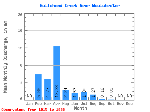
| Statistic | Jan | Feb | Mar | Apr | May | Jun | Jul | Aug | Sep | Oct | Nov | Dec | Annual |
|---|---|---|---|---|---|---|---|---|---|---|---|---|---|
| Mean | 5.93 | 4.77 | 12.34 | 2.24 | 1.57 | 1.80 | 1.26 | 0.15 | 0.09 | ||||
| Standard Deviation | 8.38 | 4.26 | 11.96 | 2.30 | 2.87 | 2.56 | 2.16 | 0.37 | 0.21 | ||||
| Min | 0.01 | 0.23 | 0.37 | 0.11 | 0.03 | 0.00 | 0.00 | 0.00 | 0.00 | ||||
| Max | 11.85 | 11.05 | 32.01 | 7.73 | 9.71 | 5.68 | 4.93 | 0.99 | 0.53 | ||||
| Coefficient of Variation | 1.41 | 0.89 | 0.97 | 1.02 | 1.83 | 1.42 | 1.71 | 2.39 | 2.36 |
 Return to R-Arctic Net Home Page