|
|
|||||||||||||||||
| Point ID: 199 | Downloads | Plots | Site Data | Code: 05AH010 |
|
|
|||||||||||||||||
| Download | |
|---|---|
| Site Descriptor Information | Site Time Series Data |
| Link to all available data | |
| View: | Time Series | All |
| Units: | m3/s |
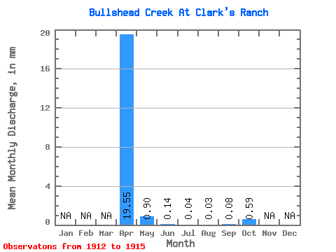
| Statistic | Jan | Feb | Mar | Apr | May | Jun | Jul | Aug | Sep | Oct | Nov | Dec | Annual |
|---|---|---|---|---|---|---|---|---|---|---|---|---|---|
| Mean | 19.54 | 0.91 | 0.14 | 0.04 | 0.03 | 0.08 | 0.59 | ||||||
| Standard Deviation | 16.09 | 0.63 | 0.09 | 0.03 | 0.04 | 0.04 | 0.71 | ||||||
| Min | 3.97 | 0.43 | 0.08 | 0.00 | 0.00 | 0.03 | 0.17 | ||||||
| Max | 35.02 | 1.62 | 0.24 | 0.05 | 0.08 | 0.10 | 1.41 | ||||||
| Coefficient of Variation | 0.82 | 0.69 | 0.68 | 0.87 | 1.73 | 0.58 | 1.20 |
 Return to R-Arctic Net Home Page