|
|
|||||||||||||||||
| Point ID: 169 | Downloads | Plots | Site Data | Code: 05AF031 |
|
|
|||||||||||||||||
| Download | |
|---|---|
| Site Descriptor Information | Site Time Series Data |
| Link to all available data | |
| View: | Time Series | All |
| Units: | m3/s |
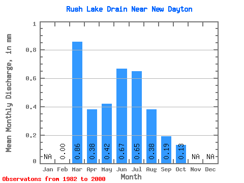
| Statistic | Jan | Feb | Mar | Apr | May | Jun | Jul | Aug | Sep | Oct | Nov | Dec | Annual |
|---|---|---|---|---|---|---|---|---|---|---|---|---|---|
| Mean | 0.00 | 0.86 | 0.38 | 0.42 | 0.67 | 0.65 | 0.38 | 0.20 | 0.13 | ||||
| Standard Deviation | 1.43 | 0.45 | 0.39 | 0.98 | 0.76 | 0.46 | 0.24 | 0.14 | |||||
| Min | 0.00 | 0.01 | 0.01 | 0.01 | 0.00 | 0.00 | 0.00 | 0.00 | 0.00 | ||||
| Max | 0.00 | 4.68 | 1.67 | 1.30 | 4.01 | 2.56 | 1.67 | 1.00 | 0.46 | ||||
| Coefficient of Variation | 1.66 | 1.19 | 0.94 | 1.46 | 1.16 | 1.22 | 1.23 | 1.10 |
 Return to R-Arctic Net Home Page