|
|
|||||||||||||||||
| Point ID: 160 | Downloads | Plots | Site Data | Code: 05AF009 |
|
|
|||||||||||||||||
| Download | |
|---|---|
| Site Descriptor Information | Site Time Series Data |
| Link to all available data | |
| View: | Time Series | All |
| Units: | m3/s |
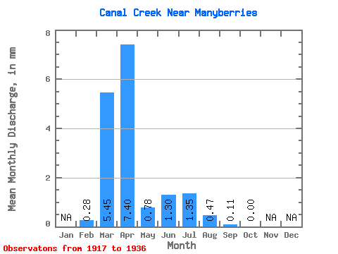
| Statistic | Jan | Feb | Mar | Apr | May | Jun | Jul | Aug | Sep | Oct | Nov | Dec | Annual |
|---|---|---|---|---|---|---|---|---|---|---|---|---|---|
| Mean | 0.27 | 5.20 | 7.07 | 0.74 | 1.24 | 1.29 | 0.45 | 0.11 | 0.00 | ||||
| Standard Deviation | 4.42 | 9.09 | 0.97 | 1.98 | 2.04 | 0.65 | 0.25 | 0.00 | |||||
| Min | 0.27 | 0.00 | 0.07 | 0.00 | 0.00 | 0.00 | 0.00 | 0.00 | 0.00 | ||||
| Max | 0.27 | 12.46 | 29.11 | 2.51 | 5.47 | 5.58 | 1.59 | 0.72 | 0.00 | ||||
| Coefficient of Variation | 0.85 | 1.29 | 1.30 | 1.59 | 1.58 | 1.45 | 2.36 |
 Return to R-Arctic Net Home Page