|
|
|||||||||||||||||
| Point ID: 155 | Downloads | Plots | Site Data | Code: 05AE912 |
|
|
|||||||||||||||||
| Download | |
|---|---|
| Site Descriptor Information | Site Time Series Data |
| Link to all available data | |
| View: | Time Series | All |
| Units: | m3/s |
| Statistic | Jan | Feb | Mar | Apr | May | Jun | Jul | Aug | Sep | Oct | Nov | Dec | Annual |
|---|---|---|---|---|---|---|---|---|---|---|---|---|---|
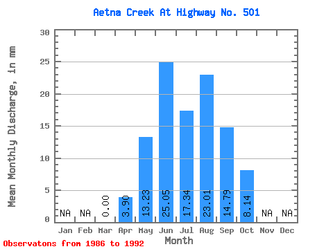
| Mean | 0.00 | 3.86 | 13.24 | 25.02 | 17.34 | 23.02 | 14.80 | 8.12 | |||||
| Standard Deviation | 5.34 | 6.38 | 7.73 | 5.44 | 10.89 | 4.72 | 3.78 | ||||||
| Min | 0.00 | 0.08 | 5.01 | 15.11 | 8.88 | 9.45 | 5.65 | 4.03 | |||||
| Max | 0.00 | 7.63 | 23.42 | 38.18 | 23.42 | 39.03 | 21.55 | 15.20 | |||||
| Coefficient of Variation | 1.39 | 0.48 | 0.31 | 0.31 | 0.47 | 0.32 | 0.47 |
 Return to R-Arctic Net Home Page