|
|
|||||||||||||||||
| Point ID: 154 | Downloads | Plots | Site Data | Code: 05AE904 |
|
|
|||||||||||||||||
| Download | |
|---|---|
| Site Descriptor Information | Site Time Series Data |
| Link to all available data | |
| View: | Time Series | All |
| Units: | m3/s |
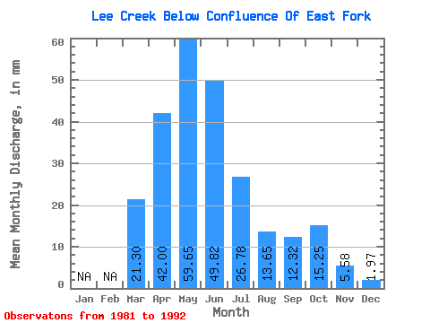
| Statistic | Jan | Feb | Mar | Apr | May | Jun | Jul | Aug | Sep | Oct | Nov | Dec | Annual |
|---|---|---|---|---|---|---|---|---|---|---|---|---|---|
| Mean | 21.31 | 42.00 | 59.63 | 49.82 | 26.77 | 13.64 | 12.32 | 15.24 | 5.58 | 1.97 | |||
| Standard Deviation | 16.61 | 25.24 | 41.28 | 29.29 | 14.85 | 10.32 | 8.26 | 15.31 | |||||
| Min | 4.22 | 6.33 | 11.88 | 20.67 | 8.14 | 4.25 | 3.70 | 3.40 | 5.58 | 1.97 | |||
| Max | 37.40 | 77.65 | 157.31 | 102.24 | 49.11 | 38.26 | 25.01 | 52.53 | 5.58 | 1.97 | |||
| Coefficient of Variation | 0.78 | 0.60 | 0.69 | 0.59 | 0.56 | 0.76 | 0.67 | 1.00 |
 Return to R-Arctic Net Home Page