|
|
|||||||||||||||||
| Point ID: 135 | Downloads | Plots | Site Data | Code: 05AE017 |
|
|
|||||||||||||||||
| Download | |
|---|---|
| Site Descriptor Information | Site Time Series Data |
| Link to all available data | |
| View: | Time Series | All |
| Units: | m3/s |
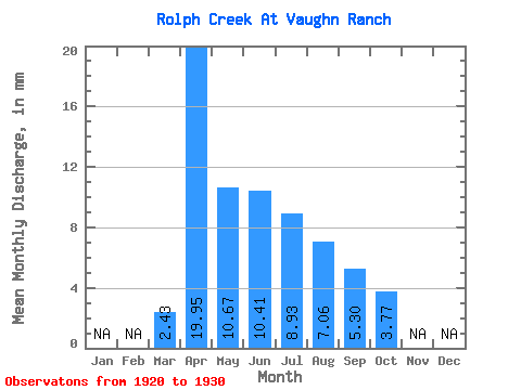
| Statistic | Jan | Feb | Mar | Apr | May | Jun | Jul | Aug | Sep | Oct | Nov | Dec | Annual |
|---|---|---|---|---|---|---|---|---|---|---|---|---|---|
| Mean | 1.84 | 15.22 | 8.13 | 7.94 | 6.80 | 5.38 | 4.04 | 2.88 | |||||
| Standard Deviation | 2.60 | 10.20 | 4.63 | 4.37 | 5.21 | 3.17 | 3.99 | 3.04 | |||||
| Min | 0.00 | 7.10 | 2.38 | 3.27 | 2.60 | 2.17 | 0.54 | 0.37 | |||||
| Max | 3.68 | 29.96 | 15.36 | 14.80 | 21.11 | 11.33 | 14.98 | 10.65 | |||||
| Coefficient of Variation | 1.41 | 0.67 | 0.57 | 0.55 | 0.77 | 0.59 | 0.99 | 1.06 |
 Return to R-Arctic Net Home Page