|
|
|||||||||||||||||
| Point ID: 116 | Downloads | Plots | Site Data | Code: 05AD041 |
|
|
|||||||||||||||||
| Download | |
|---|---|
| Site Descriptor Information | Site Time Series Data |
| Link to all available data | |
| View: | Time Series | All |
| Units: | m3/s |
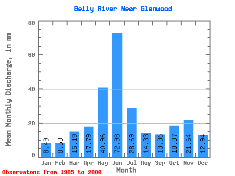
| Statistic | Jan | Feb | Mar | Apr | May | Jun | Jul | Aug | Sep | Oct | Nov | Dec | Annual |
|---|---|---|---|---|---|---|---|---|---|---|---|---|---|
| Mean | 7.86 | 7.96 | 14.06 | 16.46 | 37.89 | 67.53 | 26.55 | 13.26 | 12.36 | 17.00 | 20.03 | 11.97 | 257.58 |
| Standard Deviation | 2.36 | 4.40 | 7.91 | 11.62 | 29.01 | 70.96 | 27.14 | 11.00 | 11.14 | 7.77 | 14.40 | 7.84 | 136.07 |
| Min | 4.36 | 3.75 | 2.72 | 3.35 | 5.14 | 4.58 | 3.55 | 3.25 | 3.55 | 7.75 | 6.79 | 6.16 | 79.81 |
| Max | 12.96 | 20.46 | 31.96 | 44.19 | 83.15 | 249.34 | 93.75 | 40.76 | 43.00 | 38.84 | 46.55 | 35.91 | 580.32 |
| Coefficient of Variation | 0.30 | 0.55 | 0.56 | 0.71 | 0.77 | 1.05 | 1.02 | 0.83 | 0.90 | 0.46 | 0.72 | 0.66 | 0.53 |
 Return to R-Arctic Net Home Page