|
|
|||||||||||||||||
| Point ID: 112 | Downloads | Plots | Site Data | Code: 05AD036 |
|
|
|||||||||||||||||
| Download | |
|---|---|
| Site Descriptor Information | Site Time Series Data |
| Link to all available data | |
| View: | Time Series | All |
| Units: | m3/s |
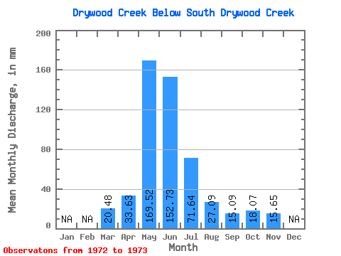
| Statistic | Jan | Feb | Mar | Apr | May | Jun | Jul | Aug | Sep | Oct | Nov | Dec | Annual |
|---|---|---|---|---|---|---|---|---|---|---|---|---|---|
| Mean | 20.25 | 33.28 | 167.79 | 151.20 | 70.89 | 26.81 | 14.94 | 17.87 | 15.49 | ||||
| Standard Deviation | 15.50 | 21.38 | 93.02 | 95.78 | 68.22 | 22.35 | 9.92 | 14.40 | |||||
| Min | 9.30 | 18.16 | 102.02 | 83.48 | 22.65 | 11.01 | 7.92 | 7.69 | 15.49 | ||||
| Max | 31.21 | 48.40 | 233.57 | 218.92 | 119.13 | 42.62 | 21.96 | 28.05 | 15.49 | ||||
| Coefficient of Variation | 0.77 | 0.64 | 0.55 | 0.63 | 0.96 | 0.83 | 0.66 | 0.81 |
 Return to R-Arctic Net Home Page