|
|
|||||||||||||||||
| Point ID: 11 | Downloads | Plots | Site Data | Code: 05AA011 |
|
|
|||||||||||||||||
| Download | |
|---|---|
| Site Descriptor Information | Site Time Series Data |
| Link to all available data | |
| View: | Time Series | All |
| Units: | m3/s |
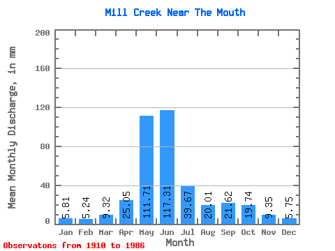
| Statistic | Jan | Feb | Mar | Apr | May | Jun | Jul | Aug | Sep | Oct | Nov | Dec | Annual |
|---|---|---|---|---|---|---|---|---|---|---|---|---|---|
| Mean | 5.80 | 5.29 | 9.32 | 25.06 | 111.70 | 117.31 | 39.66 | 20.01 | 21.62 | 19.74 | 9.36 | 5.74 | 281.94 |
| Standard Deviation | 2.14 | 1.00 | 7.29 | 12.58 | 49.69 | 74.30 | 24.11 | 15.98 | 31.46 | 17.19 | 2.90 | 1.54 | 40.75 |
| Min | 4.32 | 4.65 | 2.30 | 8.12 | 18.55 | 16.94 | 8.59 | 6.84 | 4.88 | 5.80 | 6.85 | 4.04 | 253.13 |
| Max | 8.26 | 6.45 | 32.32 | 54.59 | 218.43 | 353.32 | 103.23 | 87.37 | 175.21 | 64.33 | 12.54 | 7.03 | 310.75 |
| Coefficient of Variation | 0.37 | 0.19 | 0.78 | 0.50 | 0.45 | 0.63 | 0.61 | 0.80 | 1.46 | 0.87 | 0.31 | 0.27 | 0.14 |
 Return to R-Arctic Net Home Page