|
|
|||||||||||||||||
| Point ID: 105 | Downloads | Plots | Site Data | Code: 05AD029 |
|
|
|||||||||||||||||
| Download | |
|---|---|
| Site Descriptor Information | Site Time Series Data |
| Link to all available data | |
| View: | Time Series | All |
| Units: | m3/s |
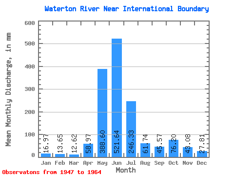
| Statistic | Jan | Feb | Mar | Apr | May | Jun | Jul | Aug | Sep | Oct | Nov | Dec | Annual |
|---|---|---|---|---|---|---|---|---|---|---|---|---|---|
| Mean | 16.97 | 13.77 | 12.61 | 58.97 | 388.54 | 521.64 | 246.29 | 61.73 | 45.57 | 76.19 | 43.07 | 27.80 | 1529.75 |
| Standard Deviation | 6.75 | 8.07 | 4.52 | 36.65 | 111.62 | 122.82 | 121.76 | 19.24 | 30.21 | 54.10 | 23.00 | 16.34 | 256.09 |
| Min | 10.11 | 8.30 | 7.38 | 17.98 | 156.50 | 346.68 | 88.71 | 36.66 | 21.38 | 13.89 | 7.58 | 6.70 | 1171.47 |
| Max | 34.14 | 34.01 | 20.92 | 144.50 | 552.34 | 795.42 | 512.17 | 115.66 | 135.11 | 174.07 | 86.35 | 67.79 | 1885.58 |
| Coefficient of Variation | 0.40 | 0.59 | 0.36 | 0.62 | 0.29 | 0.23 | 0.49 | 0.31 | 0.66 | 0.71 | 0.53 | 0.59 | 0.17 |
 Return to R-Arctic Net Home Page