|
|
|||||||||||||||||
| Point ID: 104 | Downloads | Plots | Site Data | Code: 05AD028 |
|
|
|||||||||||||||||
| Download | |
|---|---|
| Site Descriptor Information | Site Time Series Data |
| Link to all available data | |
| View: | Time Series | All |
| Units: | m3/s |
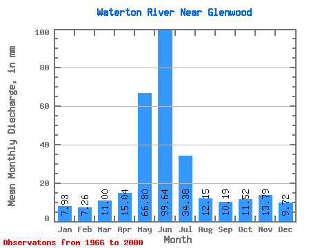
| Statistic | Jan | Feb | Mar | Apr | May | Jun | Jul | Aug | Sep | Oct | Nov | Dec | Annual |
|---|---|---|---|---|---|---|---|---|---|---|---|---|---|
| Mean | 7.78 | 7.19 | 10.80 | 14.77 | 65.56 | 97.80 | 33.74 | 11.93 | 10.01 | 11.30 | 13.54 | 9.54 | 293.54 |
| Standard Deviation | 5.44 | 4.56 | 8.41 | 12.41 | 47.37 | 79.39 | 31.40 | 11.55 | 10.87 | 9.00 | 11.47 | 8.20 | 170.28 |
| Min | 1.87 | 2.02 | 2.42 | 1.81 | 1.73 | 3.34 | 2.38 | 2.48 | 2.59 | 2.48 | 1.84 | 1.60 | 29.52 |
| Max | 24.81 | 21.26 | 34.01 | 42.78 | 144.41 | 302.13 | 107.94 | 42.72 | 43.09 | 45.18 | 41.98 | 34.83 | 636.32 |
| Coefficient of Variation | 0.70 | 0.63 | 0.78 | 0.84 | 0.72 | 0.81 | 0.93 | 0.97 | 1.09 | 0.80 | 0.85 | 0.86 | 0.58 |
 Return to R-Arctic Net Home Page