|
|
|||||||||||||||||
| Point ID: 102 | Downloads | Plots | Site Data | Code: 05AD024 |
|
|
|||||||||||||||||
| Download | |
|---|---|
| Site Descriptor Information | Site Time Series Data |
| Link to all available data | |
| View: | Time Series | All |
| Units: | m3/s |
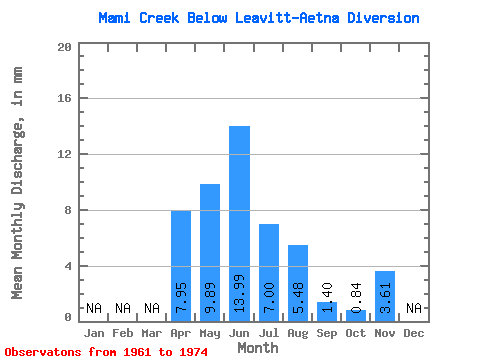
| Statistic | Jan | Feb | Mar | Apr | May | Jun | Jul | Aug | Sep | Oct | Nov | Dec | Annual |
|---|---|---|---|---|---|---|---|---|---|---|---|---|---|
| Mean | 7.99 | 9.89 | 13.95 | 6.97 | 5.50 | 1.42 | 0.87 | 3.59 | |||||
| Standard Deviation | 6.67 | 17.37 | 28.14 | 16.22 | 4.73 | 1.12 | 0.93 | 2.03 | |||||
| Min | 1.32 | 0.84 | 0.59 | 0.61 | 0.91 | 0.37 | 0.08 | 1.40 | |||||
| Max | 21.43 | 68.40 | 107.51 | 62.92 | 14.23 | 3.83 | 3.19 | 6.11 | |||||
| Coefficient of Variation | 0.84 | 1.76 | 2.02 | 2.33 | 0.86 | 0.80 | 1.07 | 0.57 |
 Return to R-Arctic Net Home Page