|
|
| Point ID: 9221 | Downloads | Plots | Site Data | Code: 15209700 |
|
| Download | |
|---|---|
| Site Descriptor Information | Site Time Series Data |
| Link to all available data | |
|
|
|
| View: | Statistics | All |
| Units: | mm |
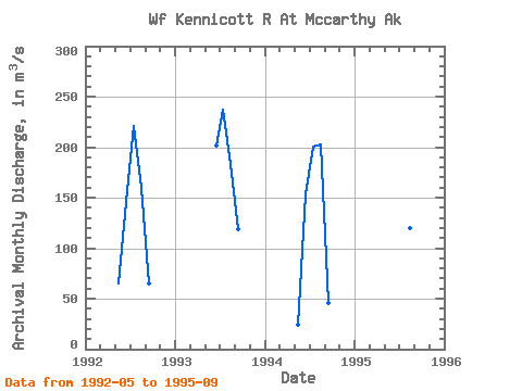
| Year | Jan | Feb | Mar | Apr | May | Jun | Jul | Aug | Sep | Oct | Nov | Dec | Annual | 1992 | 64.78 | 146.18 | 221.50 | 159.51 | 65.45 | 1993 | 202.08 | 237.07 | 183.05 | 118.59 | 1994 | 24.10 | 152.83 | 200.88 | 202.22 | 45.18 | 1995 | 136.64 | 214.91 | 119.58 | 113.66 |
|---|
 Return to R-Arctic Net Home Page