|
|
| Point ID: 8983 | Downloads | Plots | Site Data | Code: 71108 |
|
| Download | |
|---|---|
| Site Descriptor Information | Site Time Series Data |
| Link to all available data | |
|
|
|
| View: | Statistics | All |
| Units: | mm |
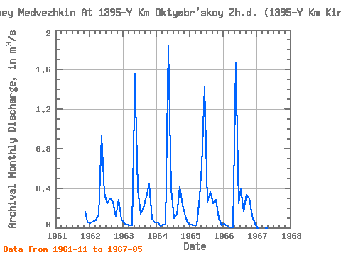
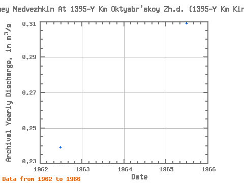
| Year | Jan | Feb | Mar | Apr | May | Jun | Jul | Aug | Sep | Oct | Nov | Dec | Annual | 1961 | 0.16 | 0.06 | 1962 | 0.05 | 0.06 | 0.07 | 0.13 | 0.93 | 0.35 | 0.25 | 0.30 | 0.26 | 0.11 | 0.28 | 0.08 | 0.24 | 1963 | 0.04 | 0.03 | 0.03 | 0.02 | 1.56 | 0.39 | 0.14 | 0.20 | 0.31 | 0.44 | 0.09 | 0.05 | 0.28 | 1964 | 0.05 | 0.02 | 0.03 | 0.03 | 1.84 | 0.39 | 0.09 | 0.13 | 0.41 | 0.23 | 0.11 | 0.04 | 0.28 | 1965 | 0.03 | 0.02 | 0.03 | 0.31 | 0.63 | 1.42 | 0.26 | 0.36 | 0.25 | 0.28 | 0.10 | 0.03 | 0.31 | 1966 | 0.04 | 0.02 | 0.00 | 0.00 | 1.67 | 0.25 | 0.40 | 0.16 | 0.33 | 0.30 | 0.12 | 0.04 | 0.28 | 1967 | 0.00 | 0.00 | 1.86 |
|---|
 Return to R-Arctic Net Home Page