|
|
| Point ID: 8076 | Downloads | Plots | Site Data | Code: 1423 |
|
| Download | |
|---|---|
| Site Descriptor Information | Site Time Series Data |
| Link to all available data | |
|
|
|
| View: | Statistics | All |
| Units: | mm |
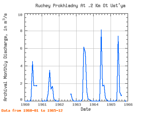
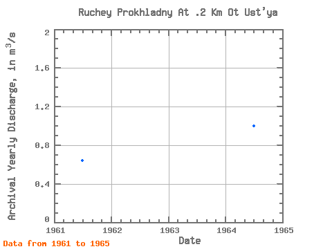
| Year | Jan | Feb | Mar | Apr | May | Jun | Jul | Aug | Sep | Oct | Nov | Dec | Annual | 1960 | 0.00 | 0.00 | 0.00 | 0.00 | 0.01 | 4.50 | 1.75 | 1.74 | 1.73 | 1961 | 0.00 | 0.00 | 0.00 | 0.00 | 0.84 | 3.51 | 1.36 | 1.67 | 0.28 | 0.03 | 0.00 | 0.00 | 0.64 | 1962 | 0.77 | 0.11 | 0.00 | 0.00 | 1963 | 0.00 | 0.00 | 0.00 | 0.00 | 0.18 | 6.16 | 5.52 | 1.02 | 0.21 | 0.13 | 0.00 | 0.00 | 1.10 | 1964 | 0.00 | 0.00 | 0.00 | 0.00 | 0.00 | 8.11 | 1.71 | 1.80 | 0.37 | 0.04 | 0.00 | 0.00 | 1.00 | 1965 | 0.00 | 0.00 | 0.00 | 0.00 | 0.09 | 7.41 | 0.99 | 0.64 | 0.22 | 0.01 | 0.00 | 0.00 | 0.78 |
|---|
 Return to R-Arctic Net Home Page