|
|
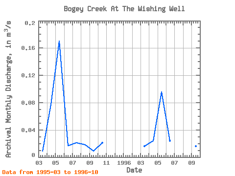
| Point ID: 7755 | Downloads | Plots | Site Data | Code: 05MF026 |
|
| Download | |
|---|---|
| Site Descriptor Information | Site Time Series Data |
| Link to all available data | |
|
|
|
| View: | Statistics | All |
| Units: | mm |
| Year | Jan | Feb | Mar | Apr | May | Jun | Jul | Aug | Sep | Oct | Nov | Dec | Annual | 1995 | 0.01 | 0.08 | 0.17 | 0.02 | 0.02 | 0.02 | 0.01 | 0.02 | 1996 | 0.02 | 0.02 | 0.10 | 0.02 | 0.02 | 0.02 | 0.02 | 0.02 |
|---|
 Return to R-Arctic Net Home Page