|
|
| Point ID: 5900 | Downloads | Plots | Site Data | Code: 1354 |
|
| Download | |
|---|---|
| Site Descriptor Information | Site Time Series Data |
| Link to all available data | |
|
|
|
| View: | Statistics | All |
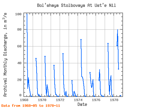
| Units: | mm |
| Year | Jan | Feb | Mar | Apr | May | Jun | Jul | Aug | Sep | Oct | Nov | Dec | Annual | 1968 | 98.40 | 9.41 | 22.40 | 11.60 | 5.16 | 0.99 | 0.02 | 1969 | 45.40 | 32.90 | 4.46 | 1.22 | 2.28 | 0.38 | 0.01 | 1970 | 47.70 | 15.60 | 0.88 | 14.20 | 7.20 | 0.58 | 0.01 | 1971 | 37.20 | 16.80 | 2.22 | 2.53 | 0.93 | 0.15 | 0.02 | 1972 | 51.10 | 16.60 | 2.55 | 1.41 | 6.13 | 0.23 | 0.01 | 1973 | 18.70 | 1.54 | 0.39 | 6.15 | 3.32 | 0.40 | 0.04 | 1974 | 67.80 | 24.00 | 23.10 | 19.90 | 11.00 | 0.85 | 0.01 | 1975 | 28.40 | 19.90 | 10.40 | 11.60 | 20.30 | 0.71 | 0.03 | 1976 | 19.70 | 31.90 | 3.26 | 1.42 | 0.82 | 0.17 | 0.00 | 1977 | 63.10 | 24.10 | 2.20 | 16.60 | 24.80 | 3.05 | 0.03 | 1978 | 60.80 | 79.70 | 32.80 | 8.05 | 7.38 | 0.82 | 0.04 |
|---|
 Return to R-Arctic Net Home Page