|
|
| Point ID: 5405 | Downloads | Plots | Site Data | Code: 05JL003 |
|
| Download | |
|---|---|
| Site Descriptor Information | Site Time Series Data |
| Link to all available data | |
|
|
|
| View: | Statistics | All |
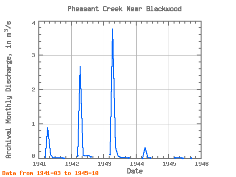
| Units: | mm |
| Year | Jan | Feb | Mar | Apr | May | Jun | Jul | Aug | Sep | Oct | Nov | Dec | Annual | 1941 | 0.02 | 0.89 | 0.09 | 0.01 | 0.00 | 0.01 | 0.00 | 0.00 | 1942 | 0.07 | 2.67 | 0.07 | 0.06 | 0.09 | 0.03 | 1943 | 0.11 | 3.77 | 0.30 | 0.07 | 0.02 | 0.02 | 0.00 | 0.00 | 1944 | 0.00 | 0.31 | 0.01 | 0.01 | 1945 | 0.01 | 0.01 | 0.00 | 0.00 | 0.00 | 0.00 | 0.00 | 0.00 |
|---|
 Return to R-Arctic Net Home Page