|
|
| Point ID: 5308 | Downloads | Plots | Site Data | Code: 05HF004 |
|
| Download | |
|---|---|
| Site Descriptor Information | Site Time Series Data |
| Link to all available data | |
|
|
|
| View: | Statistics | All |
| Units: | mm |
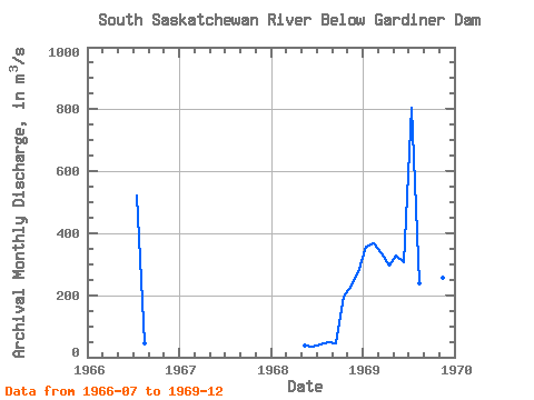
| Year | Jan | Feb | Mar | Apr | May | Jun | Jul | Aug | Sep | Oct | Nov | Dec | Annual | 1966 | 520.00 | 44.70 | 1968 | 37.10 | 35.10 | 41.80 | 48.50 | 45.30 | 195.00 | 231.00 | 275.00 | 1969 | 358.00 | 368.00 | 334.00 | 294.00 | 328.00 | 305.00 | 804.00 | 237.00 | 199.00 | 203.00 | 255.00 | 333.00 | 334.83 |
|---|
 Return to R-Arctic Net Home Page