|
|
| Point ID: 5274 | Downloads | Plots | Site Data | Code: 05HA071 |
|
| Download | |
|---|---|
| Site Descriptor Information | Site Time Series Data |
| Link to all available data | |
|
|
|
| View: | Statistics | All |
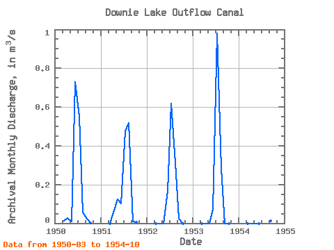
| Units: | mm |
| Year | Jan | Feb | Mar | Apr | May | Jun | Jul | Aug | Sep | Oct | Nov | Dec | Annual | 1950 | 0.01 | 0.03 | 0.01 | 0.73 | 0.55 | 0.06 | 0.02 | 0.00 | 1951 | 0.00 | 0.06 | 0.12 | 0.10 | 0.48 | 0.52 | 0.01 | 0.01 | 1952 | 0.00 | 0.00 | 0.00 | 0.17 | 0.62 | 0.31 | 0.02 | 0.00 | 1953 | 0.00 | 0.00 | 0.00 | 0.07 | 0.98 | 0.28 | 0.00 | 0.00 | 1954 | 0.00 | 0.00 | 0.00 | 0.00 | 0.94 | 0.06 | 0.01 | 0.00 |
|---|
 Return to R-Arctic Net Home Page