|
|
| Point ID: 5171 | Downloads | Plots | Site Data | Other Close Sites | Code: 03KC002 |
|
| Download | |
|---|---|
| Site Descriptor Information | Site Time Series Data |
| Link to all available data | |
|
|
|
| View: | Statistics | All |
| Units: | mm |
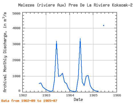
| Year | Jan | Feb | Mar | Apr | May | Jun | Jul | Aug | Sep | Oct | Nov | Dec | Annual | 1962 | 526.00 | 573.00 | 320.00 | 214.00 | 1963 | 128.00 | 67.70 | 38.70 | 54.40 | 762.00 | 3180.00 | 969.00 | 1010.00 | 1170.00 | 623.00 | 521.00 | 207.00 | 727.57 | 1964 | 80.50 | 43.20 | 31.20 | 38.20 | 864.00 | 3340.00 | 614.00 | 396.00 | 987.00 | 1030.00 | 407.00 | 222.00 | 671.09 | 1965 | 117.00 | 68.40 | 43.40 | 33.70 | 585.00 | 4170.00 | 768.00 |
|---|
| Other Close Sites | ||||||
|---|---|---|---|---|---|---|
| PointID | Latitude | Longitude | Drainage Area | Source | Name | |
| 5172 | "MELEZES (RIVIERE AUX) PRES DE LA RIVIERE KOKSOAK" | 57.67 | -1235999 | Hydat | ||
 Return to R-Arctic Net Home Page