|
|
| Point ID: 5148 | Downloads | Plots | Site Data | Code: 03FB004 |
|
| Download | |
|---|---|
| Site Descriptor Information | Site Time Series Data |
| Link to all available data | |
|
|
|
| View: | Statistics | All |
| Units: | mm |
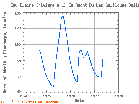
| Year | Jan | Feb | Mar | Apr | May | Jun | Jul | Aug | Sep | Oct | Nov | Dec | Annual | 1974 | 98.50 | 88.50 | 76.60 | 67.00 | 1975 | 59.60 | 54.40 | 50.00 | 48.40 | 75.10 | 97.70 | 117.00 | 143.00 | 145.00 | 128.00 | 110.00 | 89.20 | 93.12 | 1976 | 73.80 | 63.70 | 57.50 | 54.80 | 97.30 | 98.10 | 87.50 | 90.40 | 96.10 | 87.50 | 78.20 | 71.50 | 79.70 | 1977 | 66.40 | 62.90 | 61.50 | 61.60 | 94.70 | 128.00 | 125.00 | 123.00 | 117.00 |
|---|
 Return to R-Arctic Net Home Page