|
|
| Point ID: 511 | Downloads | Plots | Site Data | Code: 05ED001 |
|
| Download | |
|---|---|
| Site Descriptor Information | Site Time Series Data |
| Link to all available data | |
|
|
|
| View: | Statistics | All |
| Units: | mm |
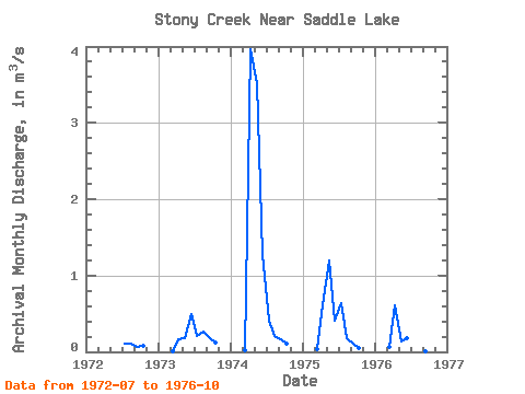
| Year | Jan | Feb | Mar | Apr | May | Jun | Jul | Aug | Sep | Oct | Nov | Dec | Annual | 1972 | 0.11 | 0.11 | 0.07 | 0.08 | 1973 | 0.01 | 0.17 | 0.18 | 0.49 | 0.21 | 0.26 | 0.19 | 0.12 | 1974 | 0.03 | 3.96 | 3.52 | 1.27 | 0.41 | 0.21 | 0.16 | 0.10 | 1975 | 0.03 | 0.62 | 1.20 | 0.41 | 0.63 | 0.17 | 0.10 | 0.05 | 1976 | 0.06 | 0.60 | 0.14 | 0.17 | 0.15 | 0.04 | 0.01 | 0.02 |
|---|
 Return to R-Arctic Net Home Page