|
|
| Point ID: 398 | Downloads | Plots | Site Data | Code: 05CE013 |
|
| Download | |
|---|---|
| Site Descriptor Information | Site Time Series Data |
| Link to all available data | |
|
|
|
| View: | Statistics | All |
| Units: | mm |
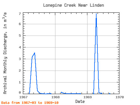
| Year | Jan | Feb | Mar | Apr | May | Jun | Jul | Aug | Sep | Oct | Nov | Dec | Annual | 1967 | 0.00 | 3.16 | 3.53 | 0.25 | 0.03 | 0.00 | 0.00 | 0.00 | 0.01 | 1968 | 0.12 | 0.03 | 0.02 | 0.02 | 0.01 | 0.01 | 0.01 | 0.02 | 1969 | 0.00 | 6.88 | 0.10 | 0.05 | 0.04 | 0.01 | 0.02 | 0.02 |
|---|
 Return to R-Arctic Net Home Page