|
|
| Point ID: 2784 | Downloads | Plots | Site Data | Code: 04AA003 |
|
| Download | |
|---|---|
| Site Descriptor Information | Site Time Series Data |
| Link to all available data | |
|
|
|
| View: | Statistics | All |
| Units: | mm |
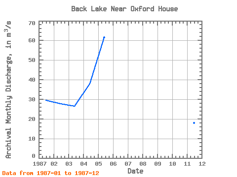
| Year | Jan | Feb | Mar | Apr | May | Jun | Jul | Aug | Sep | Oct | Nov | Dec | Annual | 1987 | 29.40 | 27.60 | 26.40 | 38.00 | 61.50 | 29.70 | 18.00 | 12.20 |
|---|
 Return to R-Arctic Net Home Page