|
|
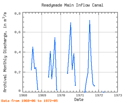
| Point ID: 183 | Downloads | Plots | Site Data | Code: 05AG013 |
|
| Download | |
|---|---|
| Site Descriptor Information | Site Time Series Data |
| Link to all available data | |
|
|
|
| View: | Statistics | All |
| Units: | mm |
| Year | Jan | Feb | Mar | Apr | May | Jun | Jul | Aug | Sep | Oct | Nov | Dec | Annual | 1968 | 0.22 | 0.45 | 0.23 | 0.25 | 0.03 | 1969 | 0.15 | 0.41 | 0.13 | 0.30 | 0.55 | 0.02 | 1970 | 0.19 | 0.40 | 0.70 | 0.22 | 0.39 | 0.07 | 1971 | 0.00 | 0.12 | 0.19 | 0.72 | 0.32 | 0.08 | 0.06 | 1972 | 0.00 | 0.11 |
|---|
 Return to R-Arctic Net Home Page